News and Analysis
Best Neighborhood publishes massive amounts of neighborhood data for users to find the best places to live and visit. From time to time we'll also publish interesting findings from our data, including correlations, maps, and data visualizations.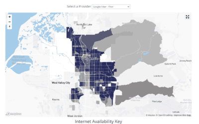
ISP Reports Leaves Us Impressed – Shopping for Internet Doesn't Suck Anymore
ISPreports.org is a new site promising two things the internet service market has been lacking: accountability for internet service providers, and better data for consumers. ISP Reports give more details and more helpful suggestions on internet service than anyone...

A Happy Meal is Never Far Away: The Average Distance to a McDonald's in the US
by Sandra Hadlock Key data points The average distance to a McDonald’s in the contiguous 48 states is 3.07 miles from your home. The shortest average distance to a McDonald’s is just 0.16 miles in Crum Lynne, PA. The farthest inhabited area from an American McDonalds...

How Elon Musk’s Starlink Will Save You Money — Even If You Don’t Use It
Published by Sandra Hadlock on August 25, 2021 SpaceX's new satellite high speed internet service, Starlink, is a promising and bold undertaking that could be a game changer for millions around the globe. With another launch coming up later this week, we ran some...
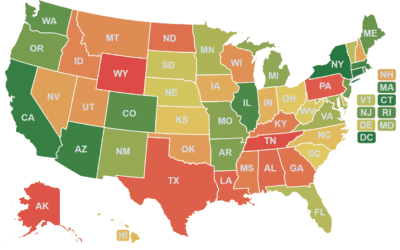
Beer per Hour: How Many Beer Could You Buy for an Hour of Minimum Wage Work? A Fixed Visualization by State
The above based on a post from reddit.com/r/dataisbeautiful. Despite reaching the top of the subreddit, it was quick to see the author had made some kind of mistake with the data, and the numbers were inaccurate. Still, we thought it was an interesting way to compare...

The Riskiest & Safest Arenas for a Potential Virus Outbreak
Published on March 27, 2021 Since at least the days of ancient Rome, humans have gathered at a central location to watch feats of physical competition take place in a centralized public building. These days, at least until recently, there are hundreds of stadiums...
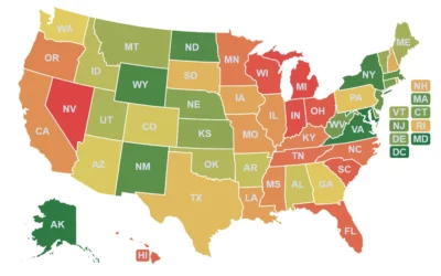
CrimeGrade.org Shows You the Safest Places to Live
Whenever we show people bestneighborhood.org, they're impressed, but immediately ask one of three questions. The most common has always been, "What about crime?" We wanted it to, but crime data is extremely daunting for many reasons. It's taken us many months to...

How Many Days Rent Will $1200 Buy in Your City?
As municipalities around the world scramble to save their local economies from the effects of COVID-19, the United States federal government is sending direct payments of $1,200 to every adult in the nation (with several stipulations). Many affected citizens have...
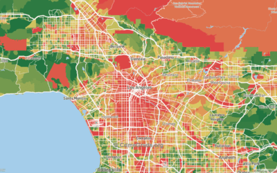
Where COVID-19 Will Hurt Most: Mapping Estimated Economic Fallout from the Coronavirus
If you'd like to jump straight to the projected economic impact by neighborhood in your city, enter your zip code below: As everyone knows, COVID-19, formerly known as the Novel Coronavirus, has caused many deaths, some panic, and many stay-in-place orders. With Best...
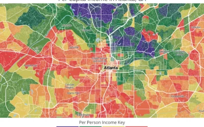
Where Racial Segregation and Income Disparity Align: Atlanta
As part of an ongoing analysis looking at racial segregation and income disparity in the United States, Best Neighborhood has created this animated map for Atlanta, GA. It's plain to see that high-income neighborhoods (purple and dark green) in...
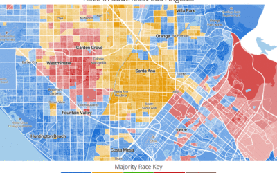
Where Racial Segregation and Income Disparity Align, Part 1: Los Angeles
Published by Carson on March 12, 2019 A new statistical analysis completed by bestneighborhood.org shows race and per-person income are associated on a neighborhood level in Santa Ana more than any other large city (150k+) in the United States. Garden Grove, Long...